Residents of the upper South Hill attended a Traffic Scoping Meeting last night held by the traffic engineer for the developer of the Regal Commons development along Regal Street. Attendees looking for answers as to the potential impact of the development and solutions to the current traffic issues on Regal were disappointed to learn the there was no real discussion of potential impacts discussed at the meeting. The developer’s engineer, Mr. Whipple, said that this meeting was to gather input from neighbors about areas that needed to be addressed by their traffic study and that results of their study would be presented to the neighborhood in a couple of months.
The only real traffic impact data shared was old data from the developer’s SEPA application back in early June stating that the total buildout of the 8 acre site would result in about 3000 trips a day along Regal Street. As we have discussed in an earlier post, this number vastly under estimates the specific land use impacts of the proposed drive thru restaurants according to rates from the International Transportation Engineers (ITE) Trip Generation Manual. The ITE Manual is the standard reference and method used in Spokane to determine potential traffic impact of various types of projects. The developer’s SEPA application has been on hold since early August while Mr. Whipple develops new trip generation estimates using more appropriate land use codes for the proposed development. He argues that looking at individual land uses grossly exaggerates the actual number of trips per day which is why he elected to use the broader land use code he originally did. However, these trip generation rates are how the City and County determine the amount of mitigation to be paid for the impact of the development. I would hope that our municipalities would err on planning for the upper end of potential impact, our City planners seem to agree and have asked for revised estimates. We will share the new numbers once they are given to the City.
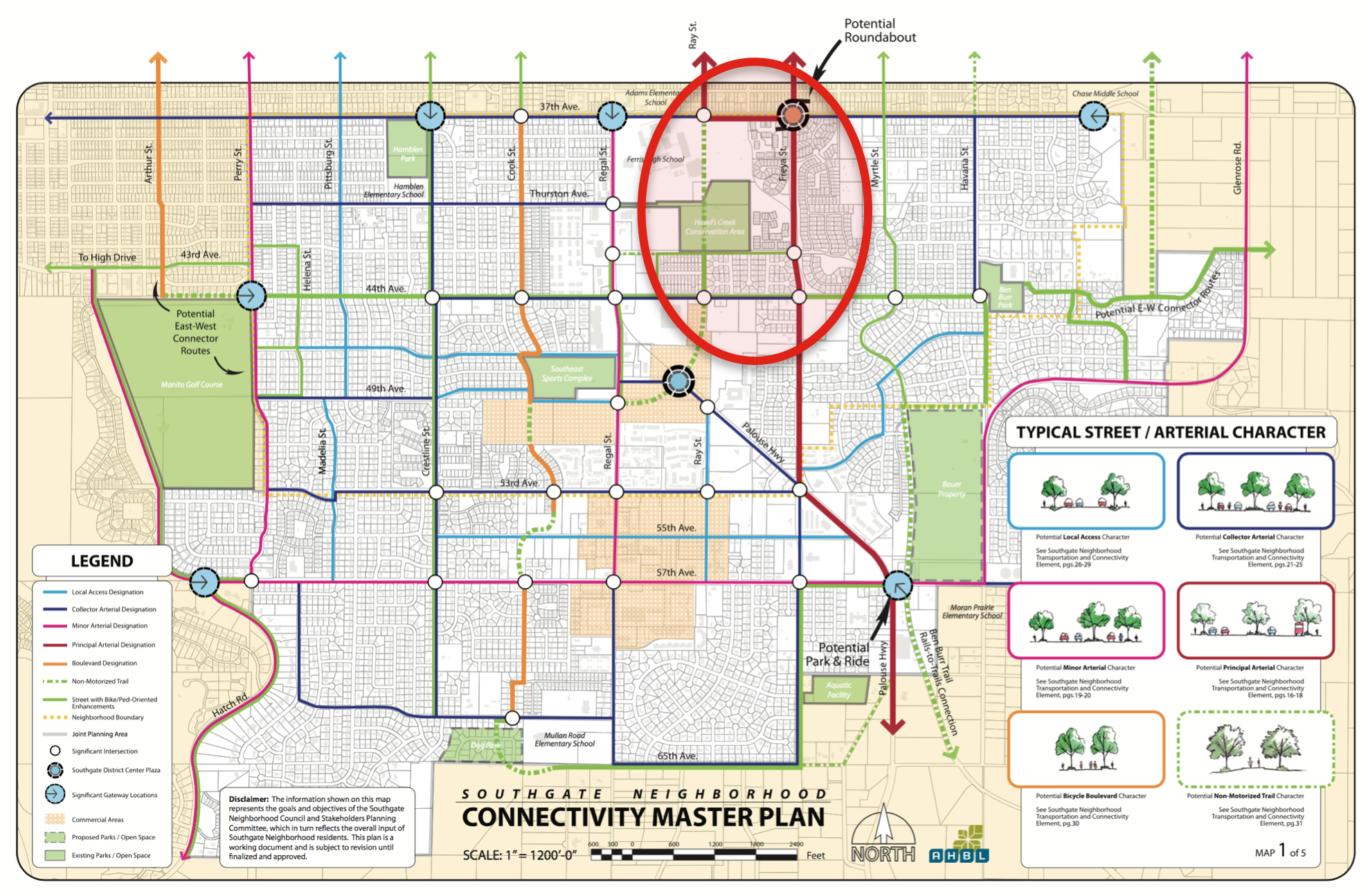
The main point of the traffic scoping meeting is to determine what intersections and parts of the road system to study for current and potential impacts from the development. In this case the City and County asked the developer to study these intersections:
- Regal and 53rd
- Regal and 55th
- Regal and 57th
- Freya and 55th
- Freya and 57th
The attendees asked that he scope be expanded to include other intersections such as:
- Freya and Palouse Hwy
- 53rd and Crestline
- 55th and Crestline
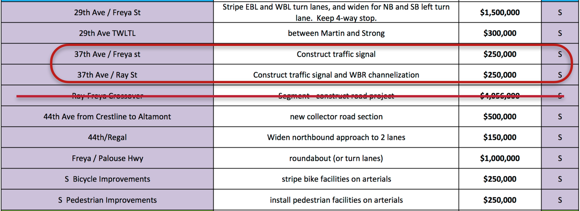
- 37th and Freya
There were a number of neighbors (myself included) that called for a broader comprehensive traffic study on the South Hill that looked not just at issues around Regal Street and 53rd, but looked at traffic patterns on and off the hill as well clear over to the Glenrose area. This is likely beyond the scope of this traffic study, but it is something area residents should pursue with the City and County to do in a coordinated and comprehensive way taking into account the full potential buildout of developable land in the City and out in the County’s Urban Growth Area.
In addition to studying current traffic levels, the study needs to account for “background” projects. These are projects that have already been approved but may not have been fully built out. Mr. Whipple said that in this case that includes the Ben Burr Apartments currently under construction at Ben Burr Road and 57th Avenue, the 55th Avenue apartment complexes, and the “Swarthout” Strip Mall at 55th and Regal. We asked that his background data also include the nearly completed Palouse Trail Apartments behind Target, the KXLY and Maverick District Center properties (there were traffic estimates associated with their SEPA applications from 2008), and the Maverick gas station/Douglass property at 44th and Regal (this property had a 7000+ ADT traffic impact assigned to it during its 1997 SEPA process). All of these projects came with hundreds, if not thousands, of vehicle trips per day associated with them. Adding them all together places Regal Street well over capacity as a designated Minor Arterial. Other items to be considered in the traffic study is a sight distance analysis along Regal at 53rd and 55th and a “Mini-roundabout” at Freya and 57th (we’re looking for more info on that).
Neighbors took the opportunity to discuss their perception of current traffic conditions along the Regal Street corridor and their experiences trying to commute along the street in recent years. KXLY News was on hand to record the event and posted a short story about it on their evening news. Suffice to say people are already experiencing extended commute times during peak traffic hours and many wanted to see Regal widened to accommodate more traffic. As has been said in the past, widening Regal is not an option since the City and County do not have the right-of-way available to put more lanes on the street. City traffic engineer Inga Note, who was in attendance, verified that fact and said there are no plans and no real way to widen Regal. It has been shown both nationally and around the world that widening roads only provides temporary relief to auto congestion. While no solutions were forthcoming at the traffic scoping meeting, the issue is now very apparent to the developer, the City, and the County.
One possible mitigation proposed by the developer is to add a traffic light at 53rd and Regal. This will not reduce traffic, but could help manage its flow, especially into and out of the new development. However, the City Capital Improvement Plan does not have this project listed and the COS Transportation Impact Program report cited by Mr. Whipple that lists a traffic signal at 53rd and Regal has not be adopted by the City, so their mitigation funds cannot be used for that project. Additionally, City policy states that traffic signals need to be placed at the intersection of designated arterials. Regal is designated a Minor Arterial, but 53rd is not. Another detail for the City to work out with the developer.
Finally, there were concerns from a few attendees about the non-auto users of the neighborhood roads. Bicyclists and pedestrians (including school kids) use Regal and adjoining roads as paths to school and businesses around Southgate. No one felt that Regal was a safe environment for these users. Mr. Whipple took the time to explain that existing conditions cannot be blamed on the proposed Regal Commons development. However, it should be incumbent upon him and the developer to make sure their project does not exacerbate these issues, especially since the zoning for their project is supposed to be pedestrian-oriented as described by both the City and County code.
Overall, there were no solution offered at the meeting last night, and there was not a clear picture of the potential impacts given either. Southgate Neighborhood Council will continue to monitor the progress of the SEPA application and notify folks of any opportunities to give comment or learn more about the state of the development.
If you have concerns and comments about this issue I encourage you to email the SEPA Application coordinator for this project, John Halsey at the City Planning Department. You can also send a note or CC our City Council representatives, Breean Beggs and Lori Kinnear.
As always if you have questions for us you can email us as well.