There are two comment periods on proposed developments closing next week. The first is an apartment complex on Palouse Hwy. just out in the County, the second is the memory care facility on Freya Street. I’ve outlined them briefly below:
Hilby Station 2 Apartments There is a SEPA Comment period open for the proposed Hilby Station Apartments that we heard about last month. This is a 32-unit apartment complex on Palouse Hwy. just south of the intersection of Freya and Palouse Hwy.
The comment period is open till Friday, October 6th and you can submit your comments to the County Planing Department by emailing Dawn Dompier at ddompier@spokanecounty.org.
Fieldstone Memory Care Conditional Use Permit We have written before about the CUP for the proposed memory care facility at 44th and Freya. The City is now seeking agency comments on the CUP and they are due by close of business Thursday, October 5th. Submit your comments to Stephanie Bishop at sbishop@spokanecity.org.
Have fun considering these two projects. I encourage all of you to submit comments, however brief to let the City and County know what you think of the ongoing development up here in Southgate.
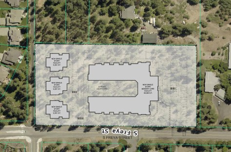
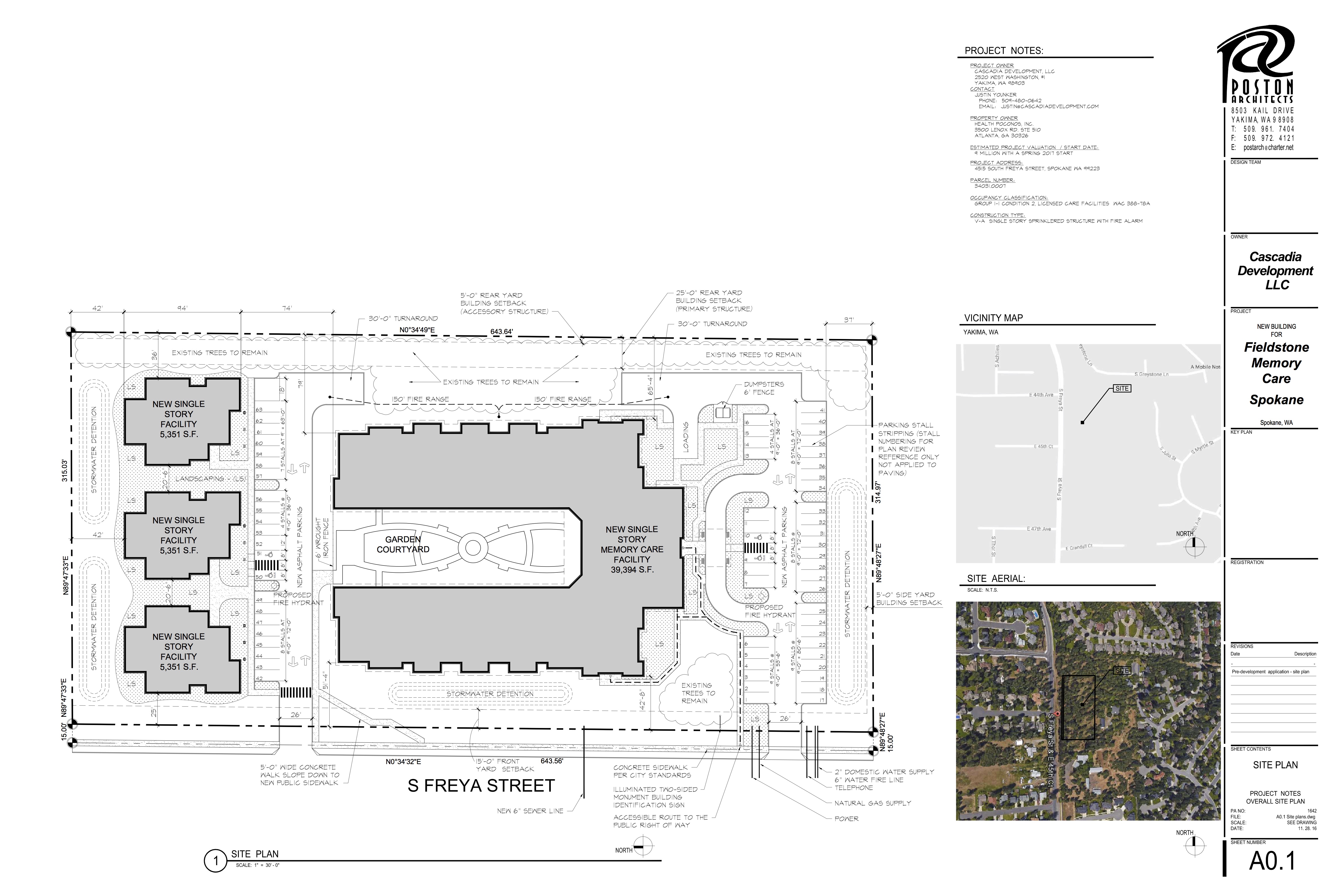
A site plan overlaid on the current aerial view of the property.
Last week the developers of a proposed memory care facility at Freya and 44th Avenue held a community meeting to discuss the proposed project in advance of their application for a Conditional Use Permit from the City to build the project.
The developers had previously held a community meeting in March and nothing had changed on the site plan. What had changed was they have now purchased the property from the previous owners and completed geotechnical work to assess the rock and soil content on site. Based on that report, they don’t see any issues with moving forward with the project. This site has been the subject of four different proposals for assisted living facilities over the years and combinations of economic health and geotechnical complexity have scuttled all the previous plans.
The developers mentioned that their plan right now is to just construct the main 39,000 sq.ft. facility and not build the three smaller structures on the north side of the property. They may build them eventually, but for now they can make the project pencil out without them. The other buildings would be constructed based on market need for more group family homes in the area.
As it stands, the project will contain 48 units with 60 beds in the main building. They will offer 24/7 nursing care with about 23 people on day shift for a 3 to 1 patient to staff ratio.. The three outbuildings would add an additional 18 beds to the facility.
The final building would look like other facilities managed by Fieldstone in Yakima and other places in Washington. The main building would be a one-story slab-on-grade structure with two wings. The main part of the building is two stories to accommodate an interior promenade and courtyard. The developers say their goal is to retain as much of the mature trees and natural landscape as they can between their facility and the properties to the east and to buffer the visual impact of the facility from Freya with screening trees and shrubs.
There were some questions about the final grade of the site on the north end given the significant natural slope of the property that direction. The developers said there wouldn’t need to be much fill to level the site and that the development wouldn’t impact the 44th Avenue Trail due to a 40′ buffer on the north side of the property. However, looking at the scaled overlay above, it appears the buildings may encroach on the trail more than discussed at the meeting. We are waiting for more detailed site plans that show final contours and grading on site. We would like to maintain as much of a natural buffer along the 44th Avenue Trail as possible. We will post those images when we have them.
As part of their construction the will be completing curb, sidewalk, and planting strips along their property adjacent to Freya to City standards. They also mentioned that their grading an site prep will not include any blasting of basalt rock on site.
For next steps they will be submitting a full application package to the City, there will likely be a traffic impact study and comment period on the Conditional Use Permit once the application has been accepted. We will keep you posted on opportunities to comment.
More Apartments Proposed for Land at 55th and Freya
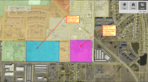
On Wednesday night Todd Whipple from Whipple Consulting Engineers came to out monthly meeting to discuss a proposed Comprehensive Plan Amendment to change the zoning of a 9 acre parcel at the corner of 55th Avenue and Freya from Residential Single Family to High Density Residential.
The parcel for re-zoning through the Comp Plan Amendment is shown in purple.
This parcel is owned by the Moody Bible Institute and it was part of the annexation earlier this year that included the apartments on 55th and the Regal Commons property. The property currently has a radio station on it, but it is zoned for single family homes. This change would allow them to build apartments on the property.
Moody Bible Institute wants to keep the existing buildings on the site, so of the 9 acres only about 8.5 will be available for development. The total number of apartments on site would be between 144 and 188. Mr. Whipple said that they would be market rate apartments, not subsidized. The land has not been sold yet, but Dennis Crapo and Diamond Rock construction are interested in purchasing it to build the apartments. If they were to build a single-family subdivision on the site it would have about 85 homes.
Development of the parcel would include building sidewalks and planting strips along the parcel frontage on Freya Street and 55th Avenue. They will also build 53rd Avenue on the north side of the property to connect to the partially completed 53rd Avenue to the west.
But Wait, There’s More…Apartments
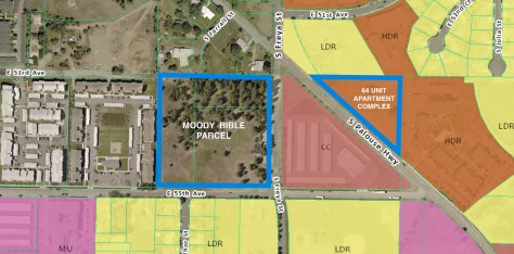
The 64 Unit Complex on Palouse Hwy. is in the County and the land is already zoned for apartments.
In the course of the meeting Mr. Whipple mentioned that there is a 64 unit apartment complex planned on Palouse Highway just south of Freya Street. These apartments are being built in the County on land already zoned High-density residential. The developer is Lancze Douglass and there should be a public comment period coming very soon.
What’s Next
For the Comp Plan Amendment, Mr. Whipple says they need to supply the City with a trip generation letter (for traffic impacts), submit a non-project SEPA application (which should include a comment period), among other documents. Their deadline for submission is October 31st. SNC will let you know when these comment periods open up. If you have questions or concerns about this, I encourage you to contact our City Council members because they will be the ones to vote on the Comp Plan Amendment next year.
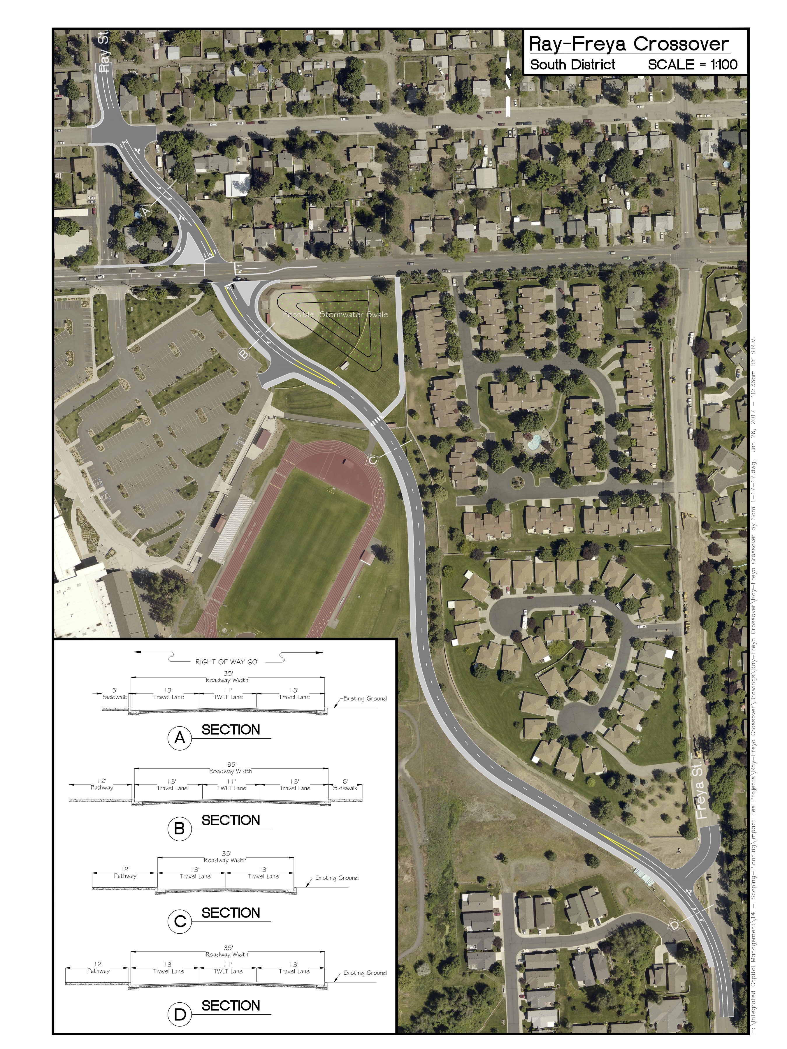
The City is currently updating the Comprehensive Plan through process they are calling Shaping Spokane. Chapter 4 of that update is the transportation chapter. When it was released in late February, we noticed that a particular project had re-appeared in a couple of places: The Ray Street Crossover
The latest proposed design for the Ray Street Crossover.
The crossover is a primarily auto-oriented route next to the campus of Ferris High School to speed access of vehicles from Ray Street to Freya Street and out to the Moran Prairie area. The crossover is shown on the arterial network on the draft Arterial Plan Map (Map TR12). This project has also been added to the 2017 DRAFT Capacity Improvement Project List referenced in Chapter 4 and found in Appendix D of Volume V (pg.41) of the new Comp Plan.
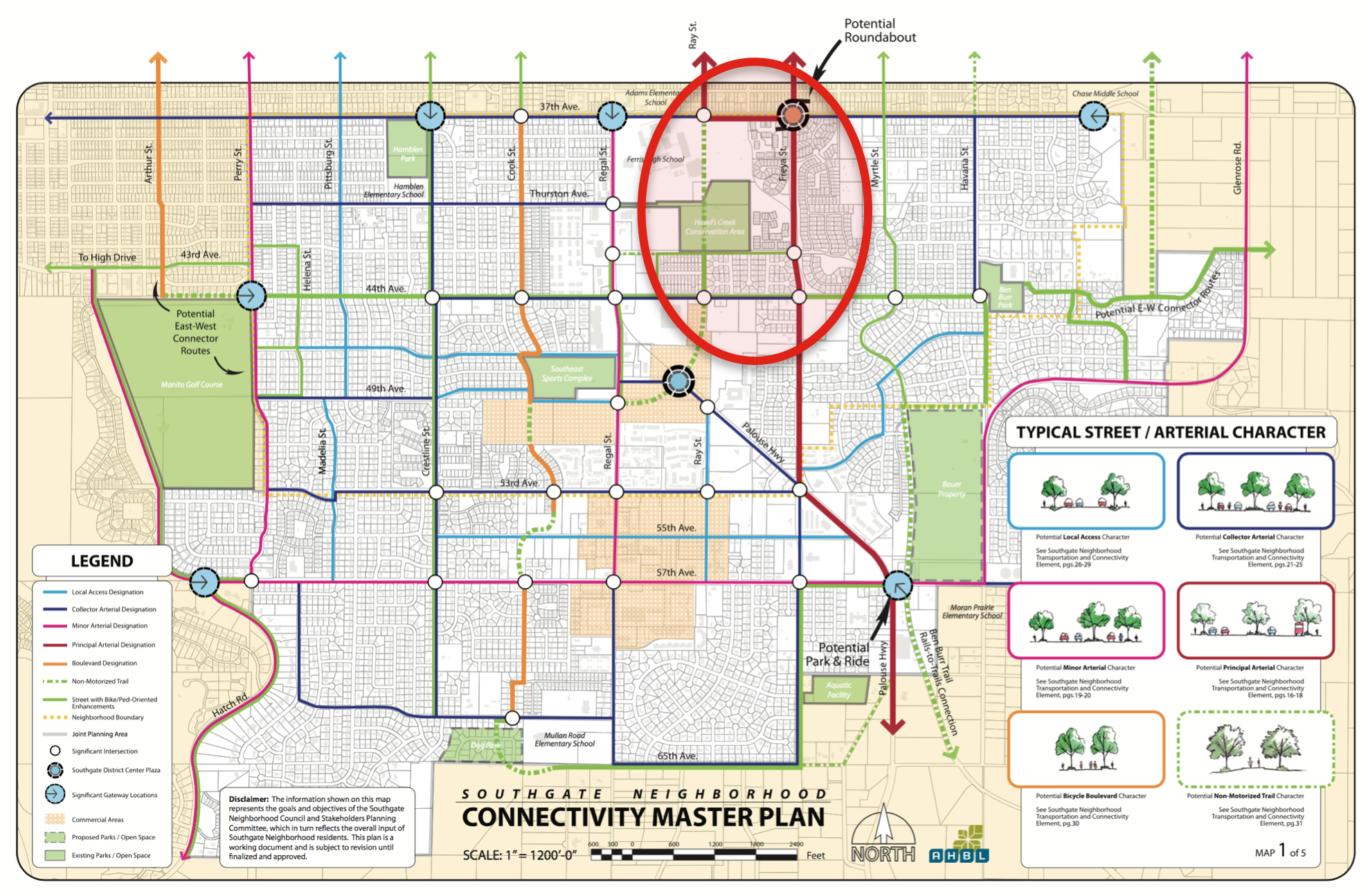
The city is resurrecting this project as a way to reduce perceived vehicular congestion on Regal Street and funnel more traffic over to our neighborhood’s designated Major Arterial, Freya Street. The crossover concept isn’t new. It was last floated back in the early 2000s (and even earlier than that), but was abandoned during the Neighborhood Planning process that took place from 2007 to 2010 because data from the City could not show how this proposed crossover would improve level of service better than signalization improvements to the intersections of 37th and Ray and 37th and Freya. For this reason, and with the concurrence of the then-current Senior Traffic Planning engineer, the city-adopted Southgate Neighborhood Connectivity Plan does not include the Ray Street Crossover (see image below).
The neighborhood arterial map from the Southgate Connectivity Plan showing no crossover, but instead suggests intersection improvements only.
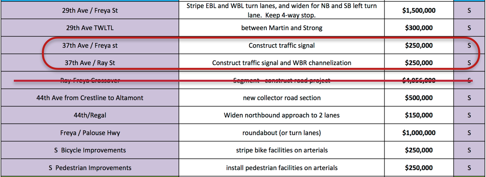
Rather, the Neighborhood Plan suggests signalization improvements at the intersections of 37th and Ray and 37th and Freya to better manage the flow of vehicular traffic. This alternative reduces impacts on Ferris, on Hazel’s Creek and is undoubtedly less costly. The table below is taken from the 2017 Draft CIP List and shows the two signalized intersections are estimated to cost $500,000 where the crossover would cost $4,056,000 and still require a signal and intersection improvements at adjacent intersections.
In addition to putting back in the Comp Plan, the City recently submitted a Roadway Capacity Justification (RCJ) report to the Spokane Regional Transportation Council (SRTC) in an attempt to justify the development of the Ray Street Crossover. The RCJ report ignores the Neighborhood Plan’s recommendations, that is the signal improvements at 37th/Ray and 37th/Freya, and instead just models traffic impacts with and without the crossover.
City staff have told neighborhood representatives that they have the ability to run the transportation model in-house. We requested that this model be run and the RCJ report adjusted to reflect the neighborhood’s preferred solution. The aforementioned 2017 Draft CIP List does include signalization of 37th and Ray and 37th and Freya as projects in the South region (see below).
Until this occurs, the Southgate Neighborhood requested to the Plan Commission and City Council that the proposed crossover be removed from the Arterial Map and 2017 Draft Capacity Improvement Project list until such time as sufficient studies have been done to address the improvements desired in the neighborhood plan. This removal would support proposed TR Goal E of the updated Comprehensive Plan, “evaluate transportation projects using objective criteria to reflect community standards and desires.” (Comp Plan, 2017, pg. 4-15)
South Hill Traffic Management: Assessing the Bigger Picture
In the larger picture, the RCJ report and portions of the draft Comprehensive Plan highlight the need for a more comprehensive assessment of traffic issues on the South Hill. The Southgate Neighborhood and South Hill Coalition have requested a that holistic Traffic Management Study and Plan be developed for the entire South Hill. This plan could assess and provide a context for any and all arterial designations and additions on the South Hill suggested in the new Comp Plan and CIP list:
The Ray Street Crossover,
the completion of 44th between Regal Street and Crestline Street,
and addition of a proposed minor collector between Southeast Boulevard and Crestline Street.
It would help determine how these individual projects and designations align or do not align with the goals of the Southgate and South Hill Coalition Neighborhood Plans. It would help these or any other projects support the existing and proposed Comprehensive Plan’s call for a “Balanced Transportation Approach” that seeks to first accommodate the pedestrian and maintain or enhance the character of neighborhoods and livability for neighborhood residents.
There will be additional hearings on the Comp Plan update at City Council in the next couple of months, so the public will have a chance to comment on this proposal again. We will also keep you updated if the City provides models for the intersections improvements called for in our neighborhood plan. Our Comp Plan and Municipal Code call for balanced, multi-modal translation development in our City, this proposal is geared primarily towards auto-users and a less dramatic, fiscally reduced solution should be considered before putting this into the Comp Plan for the next 20 years.
Southgate has received a notice that another group is proposing to develop an assisted living facility at 44th Avenue and Freya and the developer will be holding a Community Meeting on Tuesday, April 11th at 5:30pm at the Southside Community Center.
This new project is being called Fieldstone Memory Care and the site plan shared with the City at a pre-development meeting in December shows a 39,000 sq.ft. single story building with three smaller 5300 sq.ft. bungalows being built along the 44th Avenue trail on the north side of the property.
Pre-development notes from the City show the development will include 60 beds (a decrease from previous proposals). They City also indicates that they want the developers do construct full right-of-way improvements including curb, sidewalk, and pedestrian buffers along Freya. They are also encouraging the project to connect to the 44th Avenue Trail as an amenity for their residents.
This site is currently zoned as single-family residential, but it did have a Conditional Use Permit (CUP) granted in 2008 allowing development of assisted care facilities. That original CUP expired, so these developers would have to re-apply for a new Conditional Use Permit. As with previous proposals for this site, there will have to be extensive geotechnical and grading work done to make the site useable as indicated in the site plan.