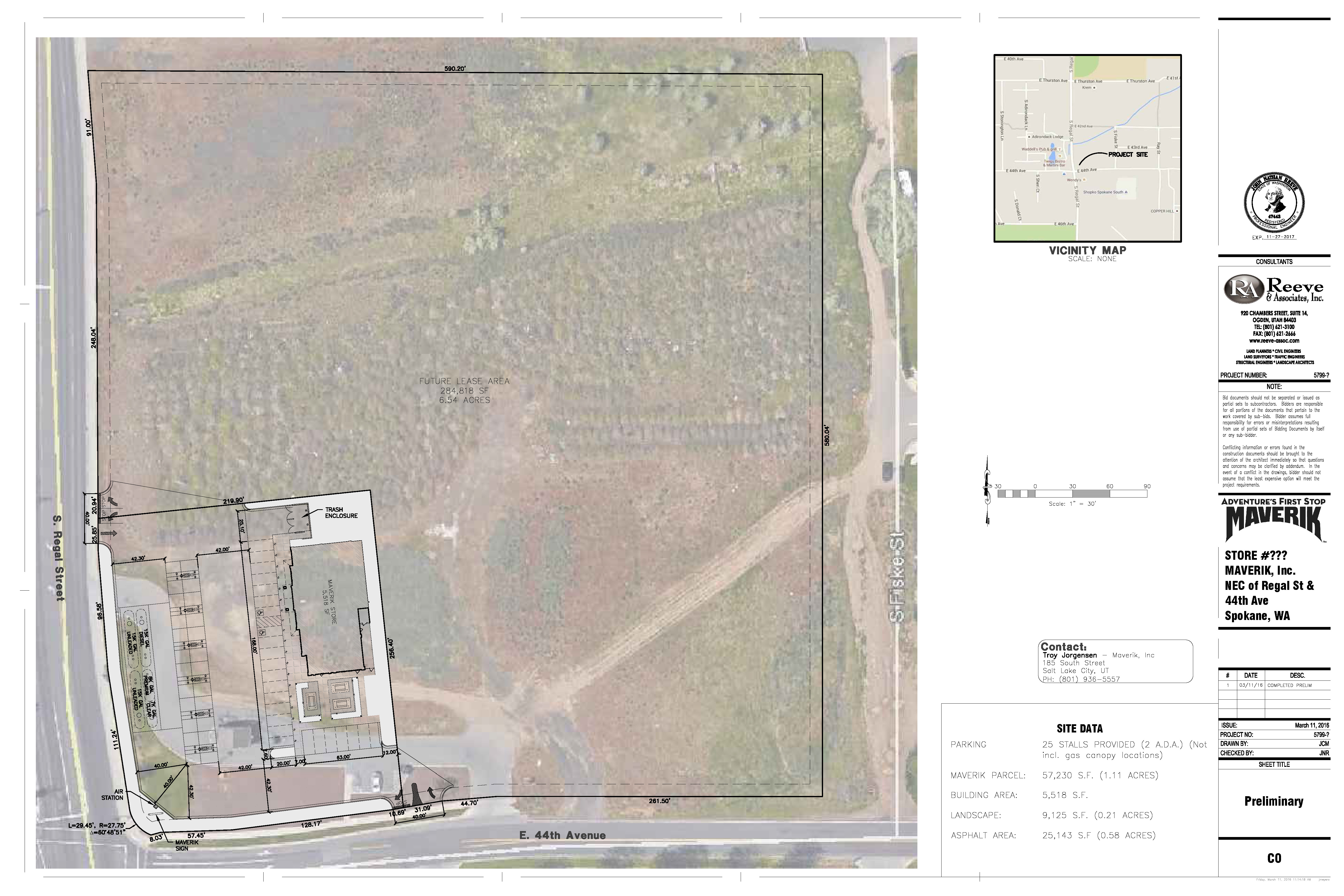
Community Meeting for New Cell Tower

Verizon is proposing to add a new cell tower over in Glenrose and they are holding a Community Meeting from 7:00-8:00pm next Thursday, July 24th at Moran Prairie Library to give some new details on location and design.

You may recall that this was discussed at one of our neighborhood council meetings back in April. Based on our input to them at the time, Verizon has moved forward with a tower design to look like a pine tree.

Take a look at these documents from Verizon for more info

Community Informational Meeting Notice

SPO Moran-RPZD_20140701

Riverfront Park Master Plan Comment Meetings

Earlier this month, the Riverfront Park Master Plan was revealed to the public and now the city is collecting public comments via email and in person at public meetings happening in May and early June.

A schedule of upcoming meetings can be found here: http://riverfrontparkmasterplan.org/events/upcoming/

You can look at the plan on the web here: http://riverfrontparkmasterplan.org/

Comments can be sent to: http://riverfrontparkmasterplan.org/contact/

The City of Spokane also announced a plan for paying for the Riverfront Park update by refinancing some existing bonds and extending them. They are holding some information meetings in May on this as well, details can be found in this news release here: https://beta.spokanecity.org/news/releases/2014/05/06/learn-about-city-of-spokane-streets-parks-funding-proposal/


Behold! The Stroad

Here is a good example of what we are trying to avoid in terms of street design in the Southgate District Center. The Atlantic shared this a month or so ago and it is applicable to our neighborhood planning situation all over Spokane.

We want to avoid a stroad at all costs.  Spokane is rife with stroads, and Regal Street could join the list if we don’t get the city to enact the District Center code requirements and neighborhood plans. A stroad is a poorly designed street that neither accommodates auto traffic well, but also does not encourage multi-modal transportation or maximize the land use around it.

Epic Planning Battles of History, Part 2: Traffic Calming

Welcome back! Now, for the second part of our Epic Planning Battles: Traffic Calming. Traffic calming is a set of road features used to create the environment that encourages pedestrian and bike uses in the District Center. Traffic calming, as envisioned by the City of Spokane, is a set of tools that can help implement our Centers and Corridors zoning and Complete Streets ordinance.

According to the City, traffic calming is, “a self-enforcing management approach that forces motorists to alter their speed or direction of travel. The purpose of traffic calming is to improve safety, especially for pedestrians and bicyclists, and to improve the environment or livability of streets for residents and visitors.” I want to emphasize that most traffic calming tactics are not meant to slow down traffic below posted limits and increase congestion, but rather encourage adherence to posted speeds and create conditions where other road users have safer access to our streets.

Given that our District Center is zoned CC1 (Pedestrian Emphasis/Auto Accommodating), traffic calming along Regal Street and Palouse Highway are a crucial part in changing the character of the area to meet the requirements of the zoning. Right now the roads through the Southgate District Center feature no bike accommodation and have pedestrian access that does not meet current city design standards; specifically a lack of any sidewalks along Palouse Highway and no pedestrian buffer strips on the sections of sidewalk we do have.

Speed limits through our District Center are currently posted at 30 -35 mph. According to the Spokane Comprehensive Plan, minor arterials in Focus Growth Areas should have a speed limit range of 20-30 mph.

Table showing desired arterial street features in Focused Growth Areas

In keeping with the precedent set in other CC1 zones, the speed limit through our District Center should be lowered to 20 mph to allow for safer bike and pedestrian use of our roads. I know people will deride this goal as only creating congestion on what they consider to be an already congested road, but looking at the amount of road effected and the reduction in speed we are talking about only 11 seconds of extra travel time along Regal through the District Center and 21 seconds along Palouse Hwy. Not a large amount of time by any standard, but a huge increase in livability and traffic calming for our pedestrian-oriented District Center.

Two big traffic calming features that create “frictional slowing” by creating the perception of a narrower road are on-street parking and planted medians. On-street parking has two benefits, it increases the amount of available parking in the District Center and the parked cars visually narrow the road (even though the lanes are the same standard width) encouraging motorists to slow down and be cautious. That’s a good thing in a pedestrian-oriented shopping district. Planted medians achieve the same effect by narrowing from the middle, increasing the perception of a narrow road and causing drivers to be more cautious and aware of their surroundings.

According to Spokane Municipal Code, on-street parking is a required feature in all Centers and Corridors. Both on-street parking and medians are key features in the street character designs in the District Center Integrated Site Plan and the Southgate Connectivity and Transportation Plan. We will not have the option of on-street parking in Southgate; the city has decided to not make our street designs align with Spokane Municipal Code and omitted on-street parking from the offsite improvements in our District Center. We are still not sure why or how this key feature was eliminated and it is part of an ongoing discussion with city planning staff. We are pursuing the inclusion of planted medias as mitigation for the lack of the required on-street parking, but have yet to reach an agreement with the city about its inclusion. They have agreed in theory to the inclusion of medias, but there is not yet agreement about how to pay for them or when they need to be built.

Ultimately, the goal is to change the character of the road to absorb the impact of increased traffic from the development of the District Center properties. As mentioned in our last post, adding a streetlight at Palouse and Regal will manage the flow of the new traffic, but it is these traffic calming and complete street elements that will provide options for people in our area to travel to the Southgate District Center in something other than a car that stand to have the most impact on increased demand.

Providing multi-modal facilities and a calm traffic environment will create a district that encourages people to get out of their cars. There will be plenty of parking (Target alone has 11 acres), but we want to make this a place you can park at and then travel around by foot, or get to without a car entirely.

Epic Planning Battles of History, Part 1: Traffic Congestion

There is a persistent myth that adding more lanes eases congestion, when in reality all it does is bring more traffic. Multiple studies going back to the late-60’s have concluded that expanding traffic lanes will initiall ease congestion, but the expansion also lowers the “cost” (in terms of time/convenience usually, but also in economic terms) of a trip and induce more cars to use the road. This is called induced demand. According to later studies, within about 5 years 80% of the extra capacity is used up and congestion returns worse than before. This raises the pressure for more capacity and further expansion into less congested areas, a condition we all know and love as suburban sprawl.

In the case of our District Center, the city has determined (on two occasions now) the level of new traffic created by development in our District Center does not warrant more lanes along Regal or Palouse (as measured by their traffic models and a result they call Level of Service). That is not to say it will be completely without effect and the city does collect traffic mitigation fees and apply them to traffic projects around the development. In Southgate they are adding the stoplight at Palouse and Regal to help make it easier for vehicles to turn left onto Regal and for pedestrians to make it across Regal. I think we can all agree getting onto southbound Regal from Palouse Hwy can be a hassle occasionally.

The measures being supported by the Southgate Neighborhood Council are aimed at making the area more usable for all types of users: auto, transit, bike, and pedestrian (an approach known as Complete Streets). This aligns with both the Spokane Comprehensive Plan that says the priority consideration for transportation use in Spokane should be pedestrian, bike, and auto, in that order (TR 1.1, pg. 12); and the the Complete Streets Ordinance of the Spokane Municipal Code, which states that all streets shall include complete streets elements. Both of these documents, as well as current best practice in urban planning, point out the need to consider more than just auto user needs on our roads.

And that is how you get back to avoiding the cycle of induced demand: options. When the “cost” of getting in your car to go to the new District Center is equal (or even higher than) to the “cost” of  walking or biking on dedicated sidewalks or trails, then we will actually start seeing reduced demand. And that is the only lasting way to relieve congestion.

The idea of creating options includes options for autos. If people feel Regal is too crowded and will only get worse, then there needs to be other route options available to them to get through or around the District Center. That’s why the Southgate Neighborhood Connectivity and Transportation Plan (with maps) makes one of it’s priorities “completing the grid”. Our neighborhood has very poor east/west connectivity. Between 37th and 57th there isn’t a single complete east/west route. Giving people better options for moving east and west across our neighborhood would relieve the pressure on Regal Street and maybe even get people home faster.

Now, creating a complete street environment will take some traffic calming, which we will discuss in the next post. I think this is a long enough post for one night, stay tuned for Part 2: Traffic Calming.

Regal Place Plaza Sculpture

A key part of the Developer’s Agreements was the stipulation that the design of the District Center include spaces for public meetings and gatherings, a community plaza. Site plans for the Black property include a plaza on the Northwest corner next to the intersection of Palouse and Regal. Initial concepts from 2011 show a wide open space from the street into the parking lot with some sort of tower in the center. Designs from April 2013 replace the tower with a fountain and shaded trellis to screen the plaza from the intersection. The latest version included in the approved building permits remove the water feature and instead show a raised planter with columnar basalt elements.

Proposed plaza design from the April 2013 plan reviewed by the Design Review Board
Plaza design from the city-approved building permits.

At our last SNC meeting, Dave Black came seeking input on the “sculpture” in the plaza and showed the plan from April 2013 to spur the discussion with meeting attendees. He also introduced us to the artist he is working with on this feature: Robert Sevilla Naudon. If you have ever eaten at Manito Taphouse or Steelhead Grill you’ve seen the result of his work and vision.

Industrial metal and high-gloss raw wood make for a striking design at Manito Taphouse.

Robert gave a very enthusiastic impromptu presentation on his ideas and vision for the project. Quick straw polls of attendees highlighted the neighborhood’s desire for a water feature (almost a unanimous consensus), some ideas of moving the feature from dead-center in the plaza to one side (to make more room for gatherings and events), and incorporation of some Palouse inspired themes (wind, grasses/wheat, and Big Rock/Basalt). Some elements of the plaza (lighting, benches, bike racks, concrete treatment) will come from the approved District Center Integrated Site Plan.

There was also some broader discussion about what kind of programming could be done with the space. Patio/sidewalk dining has been featured in the approved site plans, but neighbors also indicated their desire for music and speaker events and neighborhood fairs (craft/art, farmer markets, etc.). Dave and Robert will take that into consideration to make sure to include things like accessible power for PA systems and vendor booths.

Dave and Robert said they would take the input and work on some concepts. SNC looks forward to seeing those results and we will share them as soon as we hear back. What do you think of the plaza so far?

Bringing the Southgate District Center Vision into Focus

The past two months we’ve had discussions at our neighborhood council meetings about continued struggles getting the city to enforce the Spokane Municipal Code and Developer’s Agreements in the design of the Southgate District Center. At issue right now is the 18 month battle to hold substantive discussions about the Right-of-Way (ROW) designs in the developing District Center.  In January we drafted a summary of 5 major issues related to the ROW designs in the District Center and delivered it to all the members of the City Council and the City Planning Director. Last night the Southgate Neighborhood Council passed a resolution outlining the issues and their proposed steps to resolve them.

Major issues related to the ROW design include required features like on-street parking (SMC 17H.010.120(A)), something Southgate has been pushing for and asking to be addressed since August 2012. Additionally there is the issue of designing the street character to align with the requirements of the Integrated Site Plan, Spokane Comprehensive Plan, and the Southgate Neighborhood Transportation and Connectivity Plan. These include complete street features pedestrian crossings, speed limits, medians, and other traffic calming features (lane widths, street trees, bike lanes, etc.). Many of these ideas are touted as Best Practices in the recently released Link Spokane brochure.

When completed, the Southgate District Center should end up resembling Perry Street or Garland Avenue. The zoning and stipulations of the Developer’s Agreements fundamentally change the character of what Regal Street and Palouse Highway should be. This area could be Kendall Yards South instead it’s heading toward looking like East Sprague or North Division. Please take a moment to read our issue summary and resolution and then contact our elected leaders (District 2 Councilmen Jon Snyder and Mike Allen, Council President Ben Stuckart, and Mayor David Condon) and remind them of their commitment to creating a pedestrian oriented, mixed-use District Center in Southgate.

Mayor Condon is trying to brand Spokane as the “City of Choice”, right now the Planning Department is choosing to only enforce portions of the municipal code and binding Developer’s Agreements. I sure hope that was not the kind of choice the mayor was talking about.

Contact your legislators to stop development vesting!

Southgate residents, we have an opportunity right now to close the vesting loophole in Washington state. This is the central issue to the new housing developments over on the east side of our neighborhood in Glenrose. The State House of Representatives is considering hearings on two bills, HB 2234 and HB 2245, that would amend the Growth Management Act to stop vesting when there is an appeal before the Hearings Board.
As you remember, Southgate was party to the lawsuit against the County Commissioners for illegally expanding the Urban Growth Area (UGA) and allowing higher density development to sprawl into formerly rural land. We won that appeal, but the loophole in the current law allows developers to “vest” projects under whatever rules are in place at the time of the application, even if the land use change that allowed the new zoning is being appealed.
Since the developers could “vest” when the County illegally expanded the Urban Growth Area, they are still allowed to build their subdivisions in Glenrose (and other areas around Spokane) even though the UGA expansion was overturned and the zoning has been returned to rural. Basically we end up with suburban growth in rural areas and we as taxpayers get to pay for the expanded infrastructure, maintenance, and emergency services to support the unneeded growth.
For more on vesting and the problem it poses read this detailed article from INVW.org.
I encourage our neighbors to write to Rep. Dean Takko (chair of the House Local Government Committee) as well as our local state representatives Timm Ormsby and Marcus Riccelli in support of hearing the two bills mentioned above so that we can close the loophole and stop the unneeded sprawl of future development around the edges of Spokane’s Urban Growth Area. Reps. Ormsby and Riccelli are sponsors of bill HB2245, bill HB 2234 is being sponsored by Rep. Jon Fitzgibbon. For good measure you can contact our district reps as well: Kevin Parker and Jeff Holy.
During the UGA appeal it was messages from Spokane citizens that persuaded Governor Inslee to allow the State Department of Commerce and Department of Transportation to join the appeal UGA expansion. We need that kind of support again to encourage the legislature close this development loophole permanently and have development move forward as it should under the state’s Growth Management Act.
If you have any questions please feel free to contact me.

Tiny Target Debuts in July

The New York Times reported yesterday that about the same time Southgate’s big box Target will open in July, Target Corporation will be opening their smallest store to date: a 20,000 square foot neighborhood size store called “Target Express” in Minneapolis. This news reinforces the slow demise of large format retail as companies like Target and WalMart test smaller scale stores that will fit in pedestrian scaled, walkable neighborhoods desired by more and more people nationwide. You’ll recall Target started this downsizing trend in their company a couple of years ago with the opening of a few City Targets in places like Seattle and Portland.

This trend is coming too late for the development of the Target in our neighborhood, but can hopefully be realized as the other two Southgate District Center properties are designed and built. People aren’t looking for big box retail centers anymore, they want walkable neighborhoods with right-size amenities nearby. People are choosing well-designed, walkable neighborhoods over suburban sprawl. The sooner Spokane realizes this, the quicker we can become the “City of Choice” envisioned by the mayor.

Link Spokane: Updating the City’s Transportation Plan

The City of Spokane is updating the transportation chapter of the city’s Comprehensive Plan in 2014. On Thursday they released a 12-page booklet with the Inlander that outlines the process, the philosophy that drives it and some draft goals for the final product.

There are some great ideas in the document, some of which are already being enacted. Projects like the Crestline water main and the upcoming High Drive redevelopment incorporate some of the vision the city is talking about (combining transportation and utility projects to stretch limited funds). The big question is how these concepts, some of which are already in the current Comprehensive Plan, can be enacted in current projects like the development of the Southgate District Center.

The booklet emphasizes the need to encourage multi-modal transportation options with the goal of creating “livable streets”. Features like dedicated bike lanes, roundabouts, and pedestrian connections are held up as “Best Practices” in transportation planning and design. These are all elements of the complete streets approach Southgate Neighborhood took in developing our Neighborhood Connectivity Plan. I encourage you to look at the city’s plan and see how it melds with our neighborhood’s.

The city is encouraging public input through a series of open houses starting early next month. The full list is on the back of the brochure or can find the information on the Spokane Planning Department website. I’ve also entered the events on our website calendar. Now is the time to put this on our radar and give our input to the city since this update will set the tone for transportation planning in our area for the next 20 years.

Get Informed, Stay Involved